What You Need to Know
If you're planning to build, subdivide, or develop property in Auckland, it’s important to understand how floodplains may affect your site. Being located in a floodplain can influence what and how you can build, and it may require additional engineering work and Council approvals from what would typically be required. Knowing what qualifies as a floodplain and how it’s assessed is the first step in managing flood-related risks early in the development process.
Why Is This Important?
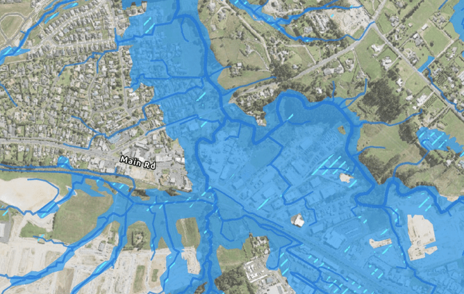
Floodplains are areas where surface water is likely to flow or collect during heavy rainfall. While most people think of rivers or streams, floodplains can also include streets, backyards, and undeveloped land — anywhere runoff can accumulate when stormwater systems are overwhelmed. Auckland Council maps these areas to guide development and help reduce the risk of property damage and unsafe building conditions. If your site is within a mapped floodplain, there may be additional requirements before you can proceed with construction or subdivision.
How Does Council Decide What a Floodplain Is?
Auckland Council identifies floodplains using specific criteria that focus on surface water flow during significant rainfall events. A key threshold is peak runoff from upstream catchments — if the flow exceeds 2 cubic metres per second during a storm, the area is generally classified as a floodplain. The modelling also incorporates the effects of climate change, including more intense rainfall and resulting impacts of rising sea levels, to capture long-term flood risk.
Are Floodplains and Flood-Prone Areas the Same – And What About Overland Flow Paths?
No — these are distinct categories of flood risk, each defined differently under Auckland Council’s flood mapping system. A flood-prone area is a localised low point in the land — such as a hollow or depression — where water can accumulate and pond during heavy rain, typically due to topography, poor drainage or limited natural outlets. These areas can flood even without significant upstream flow. Overland flow paths, on the other hand, represent the natural surface routes that stormwater takes when rainfall exceeds the capacity of the piped network. These flow paths can vary in width and depth — often taking the form of shallow, broad “sheet flow” across the ground surface, especially in flatter areas. In steeper terrain or more defined gullies, they may become narrower and more concentrated in channels, depending on local topography.
A site may be affected by one or more of these flood-related overlays — floodplain, flood-prone area, or overland flow path — and each has different implications for building placement, stormwater design, and development approvals. Understanding the distinction is key to managing risk and ensuring compliance.
What Does This Mean for Development?
If your site falls within a floodplain, Auckland Council may require certain design considerations to manage flood risk. This often includes raising the finished floor levels of new buildings to stay above predicted flood levels, ensuring overland flow paths are maintained and protected, and avoiding the placement of critical infrastructure within flood-prone areas. Identifying these constraints early helps prevent costly redesigns, delays, or compliance issues during the consent process. In many cases, a flood risk assessment prepared by a qualified engineer is needed to support the design.
What Can You Do?
The best way to check whether your site is in a floodplain is to visit Auckland Council’s GeoMaps tool. By entering your address and turning on the flood-related layers — including floodplain, flood-prone areas, and overland flow paths — you can get a clear picture of any mapped risks. If your site is affected, it’s a good idea to speak to a civil engineer at an early planning stage to understand what the implications are and what design solutions may be needed.
How CLC Consulting Group Ltd Can Help
At CLC Consulting Group Ltd, we work with developers, planners, and homeowners across Auckland to assess and manage flood risks. Our team can interpret Council floodplain data, carry out detailed stormwater assessments, and help design practical solutions that meet Council requirements without compromising your project vision. Whether it’s a new home or alteration, a multi-lot subdivision, or commercial development, we can guide you through the flood risk process and help ensure a smooth consent pathway.
If you’re planning a development and want to understand how floodplains and flood-risk might impact your site, contact us today to discuss your options.